2020 will finally be the year when people around the world realise that the effect of man-made climate change is not something that is going to occur decades from now in far-flung places, but that it is happening today and it is happening in their homes.
For the last 60 years, however, scientists, researchers, and the general public have been using images and data gathered from space to show not only that man-made climate change is happening but that it is (still) accelerating at an alarming pace.
One need only look at the maps and videos on the earth’s temperature and CO2 emissions to understand the gravity of the situation.
Temperature Visualization
CO2 in 3D
It is images and data like this, coupled with the activism of his employees that have prompted Amazon founder Jeff Bezos to launch his new 10 Billion USD “Earth Fund” “I want to work alongside others both to amplify known ways and to explore new ways of fighting the devastating impact of climate change on this planet we all share.” Mr. Bezos said earth’s climate was changing faster than predicted by the scientific community five years ago. “Those predictions were bad but what is actually happening is dire,” he said.
As Andy Penn, the CEO of Telstra recently said,[1] climate change will be the “defining challenge” of the decade.. “We need more urgent action on climate as changing weather patterns deliver more frequent bushfires, floods, droughts and storms”.
For me, as a serial space entrepreneur who during the first 30 years of my career used satellites to help provide “Universal Access” for television, telecommunications, and Internet to citizens around the world, I changed my focus about 10 years ago to “Accessing the Universe” with satellites for the good of our planet and mankind.
Space as an Observation Instrument for the earth since 1840
Today, there are already more than 1000 earth observation and weather satellites orbiting the earth, be it in geostationary or low-earth orbit.
As early as 1840, cameras were being attached to balloons provide the first-ever aerial photography, with kites following soon after. And in 1903 photos taken from carrier pigeons became the latest fad after a German engineer designed a small camera to strap on to the birds!
But the real revolution in earth observation with satellites happened in 1960 when the first US meteorological satellite, TIROS 1 (Television and Infrared Observation Satellite), was launched, sending back the first image of cloud patterns over the disk of earth. In 1972, NASA launched the Earth Resources Technology Satellite, ERTS-1, later renamed Landsat. It was the first in a long-running series of multi-spectral remote-imaging spacecraft.
Whether it be NASA, (National Aeronautics and Space Administration) with their LandSat or NOAA (National Oceanic and Atmospheric Administration ) satellites; ESA (the European Space Agency satellites such as Copernicus, https://www.copernicus.eu/en,Sentinel, https://sentinel.esa.int/web/sentinel/homeetc; be it the Saudi Arabians who with their Saudi Sats; be it JAXA, *the Japanese Aerospace Exploration Agency; etc. governments have realised the importance of using space to preserve our planet ever since Sputnik was launched in 1957.
New Space Satellites, Launchers and Vehicles are bringing the Universe ever nearer
In addition, there are now many privately funded and commercially-oriented “New Space” satellite systems. These include: Digital Globe, http://www.digitalglobe.com; and Planet, https://www.planet.com, which is one of the largest “image-processing” satellite companies in the world, thus leading to the second generation of New Space satellites. Further examples are: the precision-weather predicting Spire with more than 100 Nano Sats, https://www.spire.com/en; ICEYE with 5 SARS satellites which can detect images in darkness and at night, http://www.iceye.com; or still yet OroraTech detecting forest fires from space, https://ororatech.com; or the IoT Hiber satellite solution, https://hiber.global. Satellites are leading the way in earth observation and earth intelligence for the world.
But none of these new satellite constellations for earth observation and weather can happen unless there are launch vehicles to bring them to space. As a result, there are new companies such as Rocket Labs in New Zealand and the USA, https://www.rocketlabusa.com as well as now one of space’s stalwarts, SpaceX, https://www.spacex.com, etc. to make these satellite constellations operational. Just as with the “New Space” satellites, these “New Space” launchers are reducing the cost of accessing space exponentially (see below under the Democratisation of Space).
Internet of Things and Space: A marriage made in heaven for monitoring, analysis and precise predictions
If there is one thing that has spurred the use of space for earth observation and earth intelligence, it is the Internet of Things.
Not so long ago, computers were just accessed and used by people. Today, thanks to the advancement and miniaturisation of sensors, computers are attached to “everything” via the cloud, be it plants, pipelines, ocean floors, buildings, etc. As a result and thanks to the analysis of “Big Data” collected via all types of wireless and space technology, insights are being gained which are helping us better understand our environment, monitor the effects of climate change, and precisely predict when a catastrophic event or erosion is happening over time.
This “Big Data” which is changed into real, usable information also with the help of machine learning, better known as AI or Artificial Intelligence, is being used throughout the world by many different groups. These include: farmers for precision agriculture; large oil and gas groups for pipeline monitoring and rupture detection; and national governments for early wildfire detection and prevention. This analysis is also being done for insurance companies analysing risk on all that they insure from bridges, buildings, homes, cars. Local municipalities, small islands and coast guards are using the new insights to prepare for the impact of coastal degradation caused by rising waters. Fisheries are assessing the damage caused to coral reefs and their aqua culture. This is not to not to mention other growing applications for autonomous vehicles, and many others. Indeed, taking the temperature, pulse, pressure of our environment has become essential to the preservation of all life on the planet.
This same approach of using sensors in space to collect and analyse data is also behind the plans of the United Arab Emirates to launch their Hope vehicle to Mars later this year with three sensors – an infrared spectrometer, an ultraviolet spectrometer and a camera – which should basically help explain how, e.g. dust on Mars helped push hydrogen upward in a recent planet-wide dust storm raged on Mars in the summer of 2018.
The Democratisation of Space and Space Debris
For, just as when Henry Ford democratised cars with his famous and inexpensive Model T car at the beginning of the 20th century, thus leading to other innovations such as traffic lights and sign posting for automobiles, the current democratisation of space which has brought down the cost of accessing space sometimes as much as 1000 times will lead to other innovations.
The burgeoning of satellite constellations in Low Earth Orbit has resulted in the necessity to instigate not only a frequency and orbital assignment system such as what exists already at the ITU, but now to create and operate a global Space Traffic Management (STM) System.
Much has been made in the media about “space debris” and filling up our universe with unnecessary clutter, much the same way that we are destroying the planet’s oceans.
Whereas it is true that thanks to the miniaturisation of components which have led to a true democratisation of space and a flourishing of satellite constellations, future 3D factories, Research labs, Habitats, etc in space, it is not so much that we should not use space as described above and below, but that we have to plan and manage this valuable resource and keep it clean.
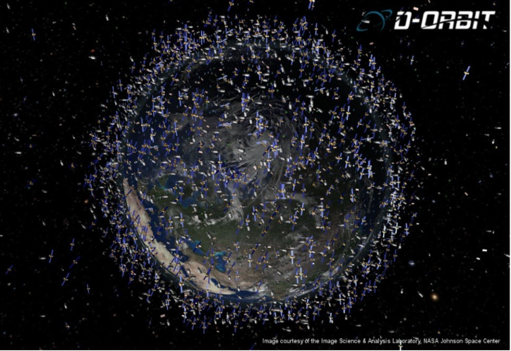
Thus, increasingly people are realising that Space Situational Awareness (SSA), is mandatory if we are to continue to be able to access space and the universe as a valuable resource. We need the ability to detect and track man-made and natural threats, predict and assess the risks involved, and provide services enabling the implementation of appropriate mitigation measures aimed at protecting space and ground assets.
I have recently proposed the creation of SMAART – Space Management Association of Assets, Resources and Traffic – based very much on the GSMA model and complementing the ITU’s work to address these issues.
The Clean Space initiative agreement recently signed between Luxembourg and NorthStar, where I am the Vice-Chair, should also inspire stakeholders in the space industry today to do all that they can to keep our universe and its resources optimally available for millennia to come. See https://www.prnewswire.com/news-releases/luxembourg-and-northstar-to-create-centre-of-excellence-for-clean-space-300977744.html
Going the next step to actually combatting climate change and preserving our mankind and the universe through space tech.
So, where as space tech is playing a crucial role in detecting, predicting, monitoring, and assessing the state of our planet and our universe, the next question which begs to be asked, is “How can space tech actually help us combat climate change and preserve mankind and the universe”?
Certainly, all of the information we are gathering via the various sorts of airborne (drones, stratospheric buses, balloons, etc.) and space vehicles is helping us identify and hopefully stop the perpetrators of this man-made disaster. It is also helping us notify in time those areas where there is no hope of mitigation and develop sustainable alternatives. A satellite system such as Kacific, http://www.kacific.com is helping Pacific islands with this critical information. Also, such applications as precision agriculture are helping us best use the available resources and there are other applications such as finding deep water in the desert which will open up new resources for us.
But there are also totally new applications which are being developed on a very large scale that will hopefully help us not only monitor, analyse and predict, but which will actually also help us find a solution to our environmental challenges. As can be seen above, ever since Sputnik was launched by the Russians in 1967, the exploration of space has helped mankind develop new solutions to be used on earth. It has also always, always been my premise and is the premise of many people that if man is the one behind this catastrophe, man should be able to provide a solution.
In addition, many of the space tech entrepreneurs and explorers today believe that by conducting the exploration of deep space, it will help us solve and perhaps even preserve our planet.
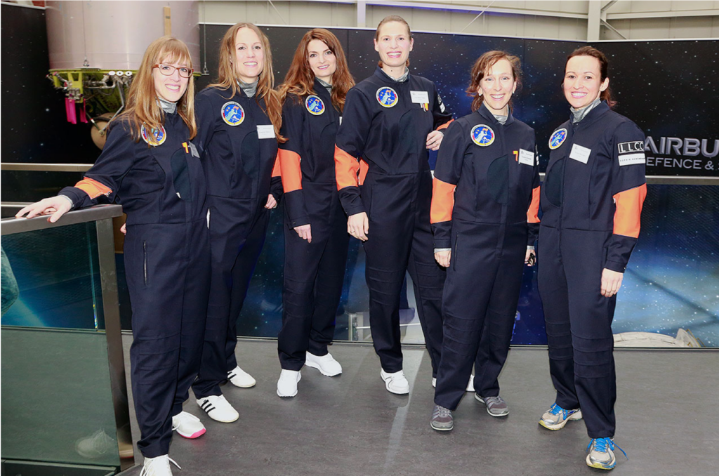
Certainly, the International Space Station (ISS) has provided a platform for this type of research and this is also why I am so excited to be helping “Astronautin”, a project coming out of Germany but which hopes to impact the whole world by sending an all-female crew to the ISS to conduct research and applications with a gender lens.
But, there are actually other shall we say ideas out there, which even a year ago seemed to me far-flung, but which no longer do. Take for instance, “In-Orbit Servicing”. This is allowing GEO satellites to extend their lifetimes of 10 – 15 years with re-fueling services. It is also allowing other satellites which have finished their useful lives to be picked up and replaced by space-buses such as D-Orbit. One year ago, these technologies and services would have seemed impossible to me. Today they are reality.
Thus, now when technologists, entrepreneurs, researchers and scientists are coming forward with what today may seem like cockamamy ideas for using space tech to combat the effects of climate change on the planet’s environment, I tend to at least give time to consider them.
Here are a few of some of the more interesting ones.
Since at least high school, Jeff Bezos has seen space exploration as a way to preserve the earth. He has posited the idea that heavy industry could be in space, leaving the planet cleaner for human use. “If you want to protect the earth, save the earth, we have to go to space to tap its unlimited resources and energy.”
Other entrepreneurs are considering putting data centres onto the moon to take advantage of the cold environment. The Chinese launched their Micius or Mozi quantum satellite into space to prepare a path for the computing power and energy necessary to unleash quantum computing’s promise, most likely indeed able to take advantage of the cold environment of space.
3D printing in space is allowing the manufacturing of an unimaginable assortment of habitats, next gen factories and industries, including perhaps one day the idea of a sun shade for the earth. First proposed by James Early in 1989, it was considered unpractical to build a 2000 Kilometre glass shield which would at once reflect the sun’s rays and shield the earth from the sun, so as to prevent global warming. Today, with robotics and 3D manufacturing, such an idea is no longer “far-flung” and scientists around the world are working on it.
Belief in the power of the human mind and of space to combat the effects of global warming and to keep our planet and universe safe
My father, General “Johnny” Johnson was one of the space pioneers who worked on the Apollo Mission at the White House for President Kennedy and President Johnson and was responsible for the first telecommunication satellites for the US Government and then the first private US domestic satellites for Western Union called WESTAR.
I remember him telling me the story of when the first satellites were launched and people asking him, “What can they possibly be used for?”
From those early days in the late 1950’s and early 1960’s, satellites and space have inspired thousands of entrepreneurs, researchers and scientists to find new ways of using space technology to make the world a better place.
I firmly believe that we shall continue this path and reach our destiny of creating a peaceful, harmonious, sustainable planet and universe for humanity.

Candace Johnson, Chair Seraphim Space Advisory Board and Vice Chair NorthStar Earth and Space as well as Serial Entrepreneur and Investor, SES ASTRA, SES Global, Loral Teleport Europe, Europe Online, Iridium, Kacific/OWNSAT (Oceania Women’s Network Satellite), VATM (Association of Private Telecom Operators), GTWN (Global Telecom Women’s Network), GBRW (Global Board Ready Women), and “Astronautin” and President Emeritus EBAN (European Business Angels Network)., Ms. Johnson is the recipient of the Luxembourg Commander of the Order of Merit, the German Officer of the Order of Merit, the Luxembourg Officer of the Oak Leaf Crown and has a Honorary Doctorate from the Hong Kong Polytechnic University as well as Masters degrees from the Sorbonne and Stanford Universities as well as a Bachelors Degree from Vassar and a high-school degree from Punahou.
[1] https://www.smh.com.au/business/companies/climate-change-defining-challenge-of-decade-telstra-chief-20200206-p53ye2.html